Bayfield Inlet

I’m back on the boat. Left here Friday night, had a nice visit home, in for a colonoscopy Monday morning – maybe TMI, but this was essentially the only non-negotiable commitment I had this month. I drove my car up here this evening.

It’s late Tuesday evening, weather warm and unsettled. Right now there’s a big thunder cell passing over with lots of rain and spectacular lightning but no wind.

As usual, my plans have been loose. But the next week or so is coming into focus. Mallory is coming to visit tomorrow, driving down from near Sault Ste. Marie where she’s been working this summer. I don’t get to see enough of her. Not making any ambitious travel plans, will hang with her in this general area for a couple of days. Then drive back to Guelph on the weekend, get dropped off on the boat next Monday or Tuesday and head out for Chicago.

I need to prep the boat for open water. Make sure everything is properly stowed, latches are secure, that sort of stuff. Cruising the canals the boat sort of turns into a house boat with stuff laying around everywhere.

I’m throwing in a picture of three Limestone 24s in Snug Harbour. That’s Sarah and Samantha too. We stopped there by car and had take out on the way home Friday.

Aground Part 3

On Friday morning Sarah dove under the boat from the side and said that everything looked intact. I had been concerned that the skeg might have broken off. She is a metallurgical engineer and is familiar with the boat, and we discussed the malleability of the skeg and rudder and agreed that makeshift repairs seemed feasible. We did a short cruise and everything seemed in good order apart from the binding in the rudder movement.

I’m planning a stop in Chicago at a yard that I used to work in and is owned and run by friends, but wasn’t keen on running the 500 miles or so to get there without a full understanding of the damage. So I started looking for a yard to haul the boat. There were several marinas in PaB but none that had equipment to handle my boat. Thought about returning to Parry Sound but didn’t want to backtrack. Then found a yard just north in Bayfield Inlet that had a travel lift. They were about a 20 minute drive away so I drove up. Found a small marina with a new travel lift. The guys there were a bit skeptical of their ability to do repairs, but I assured them that I just wanted to pull the boat for a brief inspection and that I wasn’t asking them to store or repair the boat.

I got the boat over there after a white-knuckle trip through Hangdog Channel. The wind had gone to the south and waves weren’t as bad as the previous couple of days but it was a bit unnerving imagining a steering failure while running through the rocky channel.

They were ready when I arrived at 12:00 and within 20 minutes the boat was in the air. I checked the hull first – a few areas where the gelcoat was gone, but some tapping and poking revealed that the damage was superficial.

The skeg was secure but bent about 3″ to port at the end where the rudder is secured in the shoe. The rudder was bent maybe 20 degrees off vertical. It was an easy fix. We removed the skeg, tried putting it in a vice and straightening it without success, then laid it on a concrete slab and with a sledgehammer got it straight. Then straightened the rudder with a jack and remounted the skeg. The boat was back in the water at 1:20. Total bill was $500 which I was happy to pay.

I left the boat there and returned home as I have a medical appointment on Monday but will return Tuesday to continue north. Am happy to have made it through the grounding with relatively minor damage. Lots of lessons learned that I’ll maybe outline later.

Here are some pictures of the area around Hangdog Channel. I really should have taken pics of the boat perched on the rock and the damage, but wasn’t really into documenting the event.

Parry Sound to Pointe au Baril

I took the most inside route I could, and took lots of pics.

This is the southern tip of Killbear park.

I then went up to the big beach at Killbear which is also a large popular anchorage. Think there were three boats there. Lots of room.

Taking the most inside route sometimes results in narrow passages

I stopped at Gillies Fish and Chips in Snug Harbour. Highly recommended. Took the mother ship into their dock. Bit of a tight fit but doable.

And a few other shots that I can’t remember the reason for taking


Aground Part 2

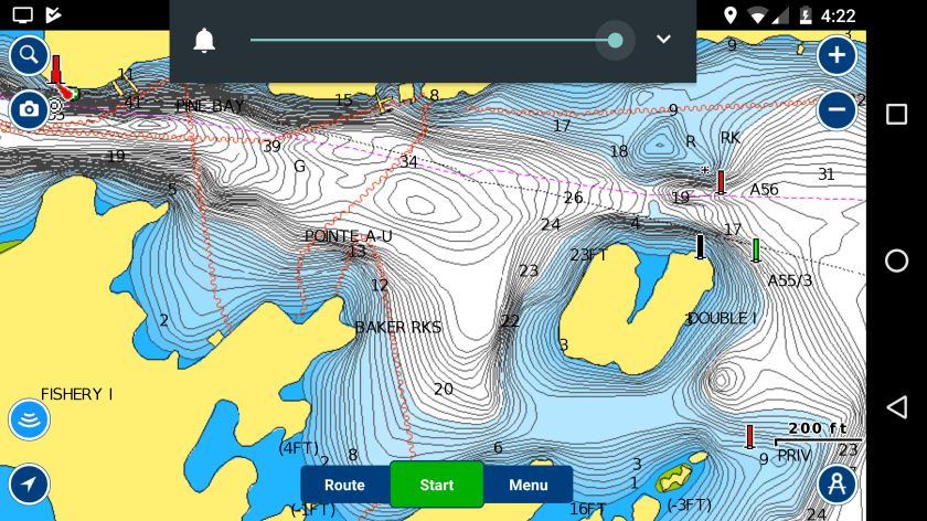
After trying half heartedly to back off whatever I hit I turned off the motor and looked more carefully at the plotters, which showed that I was atop the third island. My Navionics and paper charts also showed a green mark, which I found with my light about 20 feet on my port bow, just a painted stick almost impossible to spot at night. That stake was not shown on the Garmin plotter I had been using when I hit. If it had been I would have had a visual on the stake rather than what I mistakenly thought was the outer island.

I tried shining the light into the water but couldn’t see a lot of detail as there were small waves coming from astern and a lot of shimmering. I was in a sheltered area but there was still a 15 knot breeze.

I was really nervous about hitting the prop so after my initial strong shot of reverse I resolved not to use the motor again until daylight when I hoped to be able to do a proper assessment.

I launched my dinghy and ran my stern anchor out behind the boat (upwind), thinking that I might be able to somehow pull myself off. While the boat wouldn’t budge backwards when I tried hauling on the line I was able to pivot the boat around so that the bow was pretty much facing into the wind, and put tension on the line to hold the boat in that position. There were no sounds of grinding or bumping. Boat would be level with me standing on one side but when I shifted to the other side flopped over 10-15 degrees. And the stern seemed high, probably three inches above the normal waterline. It felt like maybe I was hung up on the rudder skeg, which is the lowest part of the boat. Checked the bilges and no sign of water entry or damage. It was now well after midnight, and I decided to settle in for the night. I climbed into my berth in a heeled boat and slept fitfully until dawn at about 5:45.

At first light I got back to work. Took a long boat hook to gauge depth and could see the bottom quite clearly. The middle of the boat was on a big weathered rock, with deeper water at the bow and stern. The list looked quite dramatic from the dinghy, with one chine completely out of the water. Deep water was close by on the port side, but it seemed that it got shallower for a few feet before dropping off. There were jagged loose stones on the starboard side that I didn’t want to get into.

A couple of boats came by early. One suggested calling 911 and the other was from a local cottage and offered support, including trying to tow me off and told me how to reach him.

I had been looking online at local facilities or authorities that could help. One concern I had was with further damaging or possibly holing the boat trying to get it off. I didn’t want to come off and start sinking. There were no yards close by that seemed equipped to help. There was a coast guard station not far away and I tried calling them on the phone but wasn’t getting an answer even after 8:00. Was considering phoning my insurance agent – I have lots of coverage including towing.

By 8:15 when a third cottager came by I felt I had a better picture of the situation and wanted to act. And these guys – a man and a woman – seemed very calm and competent. They had a very workmanlike boat, a solid aluminum work boat maybe 18 feet long with a 50 hp tiller steered Yamaha. He handled it very well.

After some discussion I asked them to try towing me off. Given their boat I wasn’t concerned with ripping the bottom out through brute force. I was pretty confident that my prop was clear and so had them hook to my stern. After a couple of attempts using my motor and with them pulling the boat slid off. Essentially I had gone on the rock from one side, pivoted almost 180 degrees, and came off the opposite side.

I did a quick check after I came off to make sure I wasn’t taking on water, then headed back inland to the town docks at Pointe au Baril. The boat seemed ok except the rudder seemed to start binding at about ten degrees one way and about 25 the other. I went slow. Got into PaB late morning, grabbed a fish and chips and had a two hour nap. Beautiful day in off the big lake.

When I woke up I looked at the inside rudder and steering gear carefully. All seemed undamaged and solid. The PO had a new stern tube put in and had beefed up the top support considerably and all seemed to be in good order. Sarah and Samantha arrived that evening, having accommodated my sudden change in plans. We slept at the town dock. I was pretty zonkered. Lots of adrenaline in the preceding 24 hours.

Here’s the area. The lighthouse and entrance to the lake are on the top left and the rock I got hung up on is shown as land on the lower right. Inside the mark that wasn’t on my Garmin map.

Aground Part 1

It happened Wednesday night and I’m just ready to talk about it here now. Pretty traumatic experience.

On Wednesday I left Parry Sound in the early afternoon. I had slept in, refueled, done some maintenance. Didn’t feel any urgency. The plan was to meet Samantha and Sarah Thursday night late in Killarney. Weather looked benign, though to be honest I hadn’t looked at a marine forecast in almost a month. The joys of inland voyaging 🙂

Had a beautiful inside passage up to Pointe au Baril, and detoured inland an hour or so to visit the actual hamlet. Nice country. Dropped the hook for a quick break and started thinking about where to stop for the evening and next day plans.

Whoa. Looking at the chart in detail I realized that there is no more protected passage. It’s into the big lake for most of the 40 miles to the south entrance to Collins Channel. I knew I could get to Killarney from there in any weather.

I knew this, but didn’t remember quite how desolate this coast is in the northern section. Islands change to rocks. In fair weather it’s beautiful. In bad weather it’s menacing. When I came through here in 2016 going south it was gloriously sunny and flat calm, and I casually threaded my way through the small boat passage with awe and wonder.

The marine forecast wasn’t looking great. Winds had been NW 15 knots all day and were forecast to go to west 20 knots overnight with building seas through the next day.

I should say that I approach open water with trepidation. It’s mostly because I get easily seasick. The boat seems ok in moderate seas. Sometimes going faster helps and I can cruise at 10-12 knots when I want to.

After some consideration I decided to continue on, and do a night time straight line offshore run to Beaverstone Bay. I could anchor there and have an easy day getting into Killarney. About 37 miles across and up to ten miles offshore. Doable as long as the waves weren’t too bad, I’d have a head sea.

I reached the Pointe au Baril lighthouse about 9:00 in the dark and headed out. 20 minutes later I turned around. Waves were short and nasty, and I was getting thrown around enough to realize that this probably wasn’t prudent, and certainly wasn’t going to be fun. Went in past the lighthouse and immediately started thinking about finding an anchorage. I was getting a bit queasy and was happy to find flat water and regroup.

I should say that unless I’m in open water with good visibility I drive from the flybridge. Guess my sailing instincts rule here. I have a bimini but hate the idea of an enclosure. I like to be exposed to the elements. Also at night I want to be able to see and hear clearly. I keep a hand held spotlight, horn, binoculars, and vhf radio there at all times and have a Garmin chart plotter there, but for the most part I keep everything dimmed way back and try to maintain good night vision. Generally it works, and I often use the binoculars at night too. Anyway, it was a nice night, clear with a moon.

I poked into one little cove just a few hundred yards from the lighthouse. There was a boat moored there and 20 feet of water and I wasn’t confident that there was sufficient room to swing so I headed out through a different route. My plotter showed a clump of three very small islands to pass by on the starboard side to get into a larger bay. The passage through was perhaps 100 yards wide. I could see the islands clearly and went through at idle speed. With a clear path ahead and a steady 20 feet depth I increase throttle a bit as I passed the islands, and about 10 seconds later ran up on the third island, which was about 2 feet underwater. I was probably going five knots.

I’m sure I had the gear in neutral before I stopped moving. It was a gentle bump followed by the bow rising. First reaction was shock. At some point shortly after I put the motor in reverse and tried a strong shot of reverse. Nothing. I was stuck.

Heading North

Just left Parry Sound. Came in yesterday around noon to drop off Miles and Chantal and stayed put as it was raining and blustery yesterday into this morning. I paid $75 to stay at the town dock overnight with power. This morning I filled fuel and water tanks and did an oil change and am now heading out for Killarney. Need to be there tomorrow night to meet Samantha and Sarah.

Several people have asked about fuel consumption. I operate in an economical way, which basically means going slow, typically 6-7 knots. I can travel faster but use much more fuel. My tanks hold about 800 l.

I went 20 days and traveled 393 nautical miles, about 750 km. I put 77 hours on the main motor and about 20 hours on the generator. Total fuel consumption was 333 litres of diesel. This is well within my target of 1 l per nautical mile, or about 4 usmpg.

Nice day now, sunny and low 20s. Wind NW about 15 knots.

Massasauga Provincial Park

I could spend a few days exploring here. Empty and remote feeling. Currently anchored in the middle of Jenner Bay. No cottages and very few boats.

https://goo.gl/maps/xKnPJ5i24B32

Samantha, Sarah and I were up here canoeing last fall, and it looks like I could travel though the whole area, although there is no depth published for the inner sections. Would have to go slow and stay alert. Would love to see how far up the Moon River we could go. But that’s for another trip.

To catch up, Miles and Chantal arrived Saturday night about 11:00 and we had a nice cruise out through Parry Sound (the water) to the tip of Killbear, where we anchored just inside the point. Played in the water in the morning then back into town to get groceries and meet up with my friends Tim and Layton who have an inland lake cottage relatively close by. Had a lovely relaxed cruise around Parry Island with them.

After leaving Parry Sound at supper time we found a lovely little cove right off the main channel. Had a stream running into it, a portage terminus to an upper lake and no cottages. Beautiful. Set bow and stern anchor in close to shore. No depth published so we felt our way in. Lots of water. The only issue was a lack of cell service. I actually hiked up the portage path about 11:00 pm to get an internet fix.

https://goo.gl/maps/DeTa31FNDH22

Today we planned to explore Massasauga Park. Came out to Sans Souci and turned back inland. This was the first spot on our list and it was pretty perfect so we’re here for the rest of the day and tonight. Miles and Chantal are going to stay ashore in a tent. Supposed to start raining tomorrow morning and all day tomorrow but we’re not more than three hours to town to drop them off.

Tomorrow after dropping Miles and Chantal off it’s north to Killarney where I’m meeting Samantha and Sarah Thursday night.

Parry Sound

Got underway about 10 and noodled my way north. Took several ad hoc inside passages and went down 12 Mile Bay. Then in past Sans Souci and through a few narrow passages on to Parry Sound. They call it something like 10 mile narrows.

Got into Parry Sound about 3:30, tied up at the government wharf and walked into downtown, wandered around, had a fish and chips. Filled my water tanks, left and day anchored out just around the corner.

I’m waiting here for Miles and Chantal, who are driving from London this evening. Hope they make it ok.

I’m completely winging it. I don’t have food for three for three days, so we’ll likely have to go out tomorrow morning to provision. Not many grocery stores where we’re going. Or restaurants for that matter.

Where are we going? North I think. But have to discuss with M&S.

Lots of very nice cottages around here, and a bunch of boat traffic is basically commuters. Not so many pontoon boats in these parts, lots of big aluminum utility boats with big outboards. And a lot of Limestone 24s. I have a history with Bruce R and a Limestone 24. Classy boat, but a bit slow by today’s standards.

Saw a new Carver 52 Coupe underway. Guess that’s a somewhat popular us$1.2m+ boat these days. A lot like the Riviera 5400 I met earlier. But edgier. Bah Humbug. Who buys these things and why?

I took this picture cause I liked the idea of walking out on this high deck early in the morning. House is in the trees.

There are lots of cool boathouses. But I thought that Peter M might appreciate this one, and the boat. Took two because when I got by it wanted a more complete view 🙂

Dunno if you can see it but a float plane was landing in front of me.

Turns out there’s quite a busy float plane operation here. They’ve been flying in and out regularly. Cruised by their dock.

30,000 Islands

I ended up spending two nights in Midland. Yesterday was super muggy when I got up and I wasn’t in a rush to get anywhere so I hung out on the boat with the AC on, did some reading and cleaning up. The pressure washer and submersible pump hung overboard work very well. Had a delightful shower in the cockpit in the afternoon. Next time I’ll take a picture 🙂 Rain last night.

This morning I went into town to see the tugfest activities, had coffee and a sandwich – thanks Jen for the local knowledge – then pulled up anchor about 2:00.

Here’s the cutest boat at tugfest

From Midland I went across to Honey Harbour, stopped for a couple of things at the grocery store there, and headed north into the 30,000 islands.

Wow. I spent some time around here two years ago and marveled then at the area. It’s better than I remember. I took the most inside route I could find through the islands.

A couple of hours from Honey Harbour and the cottages and boats start to thin out.

I’m now anchored in a small channel between two islands. It’s uncharted but because the water is so clear and I draw less that 3′ it’s easy to navigate from the flybridge. Dodged a couple of rocks coming in and am now snug, with a bow and stern anchor holding me in place. There is nobody around apart from a few sailboats anchored in the large cove around the corner.

I took a few pics coming up here but the day was pretty grey. Won’t waste the bandwidth on posting them here. But I’m sure there will be lots more!

Tomorrow I’m going to end up somewhere where Miles and Chantal can reach me by car. Am thinking Parry Sound. Then we can stock up before heading out for a few days exploring the area. Weather looks benign for the next couple of days.

Midland

Had a very relaxed day cruising down to Georgian Bay. It’s funny doing the reverse trip – I came down from Lake Huron to Trent two years ago and encountered my first lock in this boat then. It was a whole bunch of new experiences then. Now I feel like an old hand and can relax and enjoy myself.

I rescued a boater in distress today at Big Chute. A family in a bowrider had lost power and were frantically paddling while being sucked towards one of the gates. Lots of current. Fortunately there’s a buoyed wire preventing boats and swimmers from getting swept over the dam and they ended up pinned on it. I was able to back up to them, get a tow line and tow them to a nearby dock. The Big Chute railway guys were impressed.

I meant to take pictures but had phone charging issues. I bought two new cords in Orillia earlier this week, as well as a new mount for my tablet which I use as a plotter at the lower helm. The first cord was destroyed when the new mount dropped the tablet shortly after leaving the dock and the second turned out to be the wrong kind. Got a couple at Big Chute before my phone died.

When I got out of Port Severn I wasn’t sure where to go next. Thought about going up to Honey Harbour but also wanted to get new phone cords. So I came over to Midland. Anchored in Cheapskate Cove which was nicely sheltered from the NW breeze. It’s just me and a Swan 51 here. Flat calm now.

The weather was a bit strange today. As I was pulling into the Swift Rapids lock it started raining. While we were in the lock it absolutely poured. This is a super deep lock, the highest on the TS with a 47 foot lift. It was like being in a giant shower stall. The rain ended shortly after we left the lock. By the time I got to Midland about 4:30 it was stinking hot and I retreated to the dark air conditioned cabin for the evening.

It’s supposed to rain for the next couple of days and there’s a tug festival going on here. I have guests arriving Saturday night and I was planning to be farther north, but there’s lots to see and do around Honey Harbour. I still have to clean and organize the interior so can use time not travelling

Here are the Big Chute pics before my phone died. I’ve got to say it’s scarier going down than up. Very cool machine.